The Donkeys' Trail
( History of an ancient trail to transport salt through the Spessart )
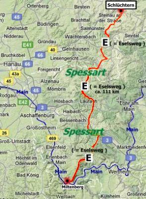 The Donkeys' Trail is a hiking trail in Hesse and Bavaria across the Spessart. He is 111 km long and leads from Schlüchtern (Hesse) to Großheubach (Bavaria) near Miltenberg.
He is one of those "Altstraßen (old streets)" called paths and he was more than twenty centuries of great importance. (Altstraßen = these are historic streets, paths and trails, which are still recognizable in most of their course today). Celtic warriors, Roman traders, imperial couriers, bishops, counts, and knights were on their way in this gray antiquity and also poor peasants and honorable / honest glassmakers. He became known by the salt caravans of "Bad Orb", who once walked along this path with their donkeys, which was loaded with heavy bags of salt. And that gave this trail its name, still today commonplace. "Via asina" is to read on old maps. The trail goes on a height of 400 to 500 meters almost exclusively through the dense forest without touching the valleys and villages and he extends 111 km through the "Spessart" from Schlüchtern in the northwest via Bad Orb, Heigenbrücken, Weibersbrunn, Hundsrück, Engelberg cloister up to Großheubach on the Main in the south-west. From here the salt (the "white gold") was transported farther south (e.g. to Nuremberg and Augsburg).
(Source: Harald Rixgens https://www.fernwege.de/fileadmin/walk/downloads/ebook/d_eselsweg_2013_a5_ebook.pdf)